Glasgow’s excess mortality: blame deprivation and housing?

Guardian Healthcare Professionals Network has just published an article by me on cities, health and data. This gave me the chance to revisit what has been a puzzle: what is the cause of Glasgow’s excess mortality, which sees men there dying nearly a decade earlier than in the longest-living urban area in the UK (Kensington and Chelsea)?

The Glasgow Centre for Population Health has been working to find answers, and it has a couple, provisionally. Firstly, it thinks that Glasgow’s deprivation is deeper than the data – which tends to measure whether people are below a threshhold (and therefore qualify for a benefit) – suggests. Secondly, it believes that Glasgow had a particularly bad legacy of poor post-war housing, such as the Red Road tower-blocks that the city attempted to demolish at the weekend.  There are other factors too. Continue reading “Glasgow’s excess mortality: blame deprivation and housing?”


Online mapping: Google, OpenStreetMap and Ordnance Survey

For ComputerWeekly.com, I have explored the options available for online mapping and how they are used by councils. Google Maps, OpenStreetMap and Ordnance Survey’s open services all have strengths and weaknesses.

Google Map Oxford
Google Map of central Oxford
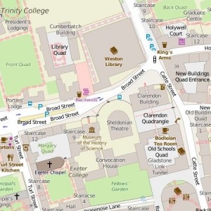
OpenStreetMap Oxford
OpenStreetMap of same area

Google Maps are familiar to most people and good on roads, but weak on many other features. OpenStreetMap is in some places excellent – just look at how the two compare in central Oxford, and who knew the Weston Library, not even named on Google, was next to the Cumberbatch Building? (No, not named after Benedict Cumberbatch.)

OpenStreetMap includes details no-one else has such as cycle routes and private paths, but as a crowdsourced operation quality varies. Of course, anyone who wants to can help with improving it. If you just want a map image you can use as you wish, it’s the place to go; just click on the ‘share’ box and arrow logo on the top-right of the screen.

If what you’re mapping is within Great Britain, Ordnance Survey has the most consistent mapping at a uniformly high quality. Its OpenSpace web map builder looks good and is fairly easy to use, although you do need to get an API key and there are a few wrinkles. For example, the HTML code it produces can be used in WordPress, but you need to install a plug-in to make it work. I also cut out some header and footer data in what OS passed on; this could all be a bit easier. Continue reading “Online mapping: Google, OpenStreetMap and Ordnance Survey”

Five ways telehealth could be used in the health service of the future

Digital technology offers new ways for doctors and patients to communicate, share results and plan and deliver care

In short: video appointments from patients’ homes; video and data appointments between NHS sites; remote analysis of data gathered by patients; distribution of results directly to patients and mental health treatment. Continue reading “Five ways telehealth could be used in the health service of the future”

Plymouth Community Healthcare: happy outside the NHS

Guardian Healthcare Professionals Network has just published two articles by me. The first is on Plymouth Community Healthcare, an expanding healthcare company running NHS and social care services in and around the city.

The organisation argues that its status as a not-for-profit, no-shareholders community interest company is better than being part of an NHS trust. It reckons the services it runs are often lost within trusts focused mainly on acute or mental health; that it is more flexible and in tune with local needs; and that it is able to focus its spending on its local area, which NHS trusts can’t do. Continue reading “Plymouth Community Healthcare: happy outside the NHS”

Cameron, the EU and Scotland and the NHS internet of things

It would be interesting to see all of these topics into a single article, but this is to cover two recent articles. The first, for Beacon, looks at the two big gambles for David Cameron’s government over the next five years: Britain’s place in Europe or Scotland’s place in Britain.

Sex, Lies and the Ballot BoxMy guess is that Mr Cameron is more likely to win than lose on both (in the case of Scotland, through avoiding another referendum) by the time he stands down, but neither are anywhere near a safe bet. Continue reading “Cameron, the EU and Scotland and the NHS internet of things”