EU Settlement Scheme needs to level-up locally

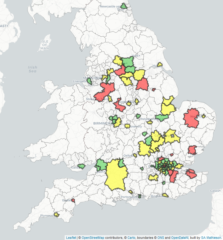
It would be nice if all data was easily comparable and highly accurate, but it’s not. Office for National Statistics numbers on nationality of people in local authority areas are rounded to the nearest thousand to reflect the fact they are survey-based estimates. The ONS recently pointed out a range of problems involved in comparing this dataset to Home Office data on applications to the EU Settlement Scheme.

I still made these comparisons for PublicTechnology, because the differences between areas are huge. Excluding Irish citizens (who generally don’t need to apply to stay in the UK post-Brexit), the number of applications to the EU Settlement Scheme is equivalent to about three-quarters of 3.6 million European citizens in the UK. But for Bassetlaw in Nottinghamshire and Sevenoaks in Kent, it is around one-quarter.

Map of EU Settlement Scheme applications and non-Irish European populations Continue reading “EU Settlement Scheme needs to level-up locally”

Littler Britain: the 14 council areas with falling populations

The Office for National Statistics has just published its annual population estimates for mid-2018. I have updated a map I first produced two years ago, showing how each area’s population has changed between 2008 and 2018. As well as the colour-coding, you can see the percentage change by hovering over an area. The data is derived from sheet MYE5 of this spreadsheet.

There are 14 council areas whose populations have fallen over the decade (shown in blue), while the UK’s population as whole grew by 7.5%. Most of them are rural and coastal areas: in England they include Cumbria, the Isles of Scilly and (an exception to the rural bit) Blackpool; in Wales, Ceredigion, Powys and Blaenau Gwent. In Scotland, seven council areas have fallen in population, mostly on the west coast: Argyll and Bute, Dumfries and Galloway, Na h-Eileanan Siar (the Western Isles), Inverclyde, North Ayrshire, South Ayrshire and West Dunbartonshire.

Continue reading “Littler Britain: the 14 council areas with falling populations”

Cornwall’s communications coast: satellite, wireless and cable

With February’s Geek’s Guide to Porthcurno, I have now written a trilogy of pieces for The Register on globally important communications sites in the west of Cornwall. The first was on Goonhilly, the satellite earth station which received the first transatlantic TV pictures in 1962, which is finding a new lease of life as a commercial deep-space communications station. Sadly, it remains closed to most visitors, as Goonhilly’s boss Ian Jones focuses on building a sustainable business. Continue reading “Cornwall’s communications coast: satellite, wireless and cable”

Dev-Olympics Rio 2016 medal table: East of England triumphs

Team GB’s medal-winners from Rio 2016 come from all over the country and beyond, as this interactive map of those winning individual medals shows. (Click on a circle for data on each medal-winner.)

Continue reading “Dev-Olympics Rio 2016 medal table: East of England triumphs”

Injured at Glastonbury? Three little words will help medics find you

New app What3Words, also used by emergency teams in a cholera outbreak in Tanzania, can help medical services locate ill festivalgoers amid a sea of tents

What3Words, which provides addressing services that work in the most desolate corners of the earth where people live in the most basic conditions, also covers the Glastonbury Festival.
Continue reading “Injured at Glastonbury? Three little words will help medics find you”