Posts

Decode a GB postcode with Postcode-decode

As a development of my recent work on online maps, I have built Postcode-decode, an online service which tells you interesting stuff about any Great Britain postcode.

Instructions: type in a postcode for a location in England, Scotland or Wales (with or without the space, in capitals or lower case), and hit Decode it. That’s it. Try it here.

Most of the data, as well as the map, is courtesy of Ordnance Survey’s OpenSpace API. (It’s great to see Ordnance Survey offering so much open data, given where it’s come from.) The calculations for longitude, latitude and distance are made by Jonathan Stott’s PHPCoord code, which is his copyright and available under the GNU General Public License. Westminster constituency data (which Ordnance Survey could consider putting into a future version of OpenSpace) comes from MySociety. Continue reading “Decode a GB postcode with Postcode-decode”

Glasgow’s excess mortality: blame deprivation and housing?

Guardian Healthcare Professionals Network has just published an article by me on cities, health and data. This gave me the chance to revisit what has been a puzzle: what is the cause of Glasgow’s excess mortality, which sees men there dying nearly a decade earlier than in the longest-living urban area in the UK (Kensington and Chelsea)?

The Glasgow Centre for Population Health has been working to find answers, and it has a couple, provisionally. Firstly, it thinks that Glasgow’s deprivation is deeper than the data – which tends to measure whether people are below a threshhold (and therefore qualify for a benefit) – suggests. Secondly, it believes that Glasgow had a particularly bad legacy of poor post-war housing, such as the Red Road tower-blocks that the city attempted to demolish at the weekend.  There are other factors too. Continue reading “Glasgow’s excess mortality: blame deprivation and housing?”

New maps with Mapbox

Key to map

Following my exploration of alternatives to Google Maps for ComputerWeekly.com, I have transferred my map of articles to Mapbox, which relies on OpenStreetMap. The data on the articles is held in a Google Sheet, and can be shown in a number of styles through Mapbox. There are alternative versions, covering all of Britain and Western Europe, elsewhere on the site. Continue reading “New maps with Mapbox”

Oxford Bodleian Library’s Book Storage Facility (in Swindon)

Oxford is a very crowded place, and it is very hard to build anything there. As a result, the greatest single part of the University of Oxford Bodleian Library collection – the Book Storage Facility, holding 8,328,367 books (and roughly 1.5m maps) on the day I visited – is not actually in Oxford, but on the Keypoint trading estate just north of the A420 on the edge of Swindon.

The beautiful new Weston Library on Broad Street, opened last spring, would not exist without the Book Storage Facility, because the latter holds all the books that were previously stored in the space that is now the atrium and exhibition space (including the Sheldon Tapestry Map of Worcestershire, featuring Chipping Norton). And the Book Storage Facility would not exist without a load of IT: the environmental control systems, the Bodleian catalogue and the software that works out the routes for the pickers that retrieve and return items to the huge 11-metre high shelves. Continue reading “Oxford Bodleian Library’s Book Storage Facility (in Swindon)”

Online mapping: Google, OpenStreetMap and Ordnance Survey

For ComputerWeekly.com, I have explored the options available for online mapping and how they are used by councils. Google Maps, OpenStreetMap and Ordnance Survey’s open services all have strengths and weaknesses.

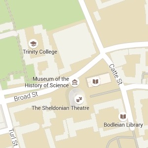
Google Map Oxford
Google Map of central Oxford
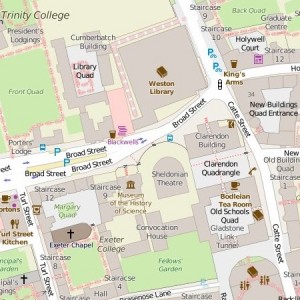
OpenStreetMap Oxford
OpenStreetMap of same area

Google Maps are familiar to most people and good on roads, but weak on many other features. OpenStreetMap is in some places excellent – just look at how the two compare in central Oxford, and who knew the Weston Library, not even named on Google, was next to the Cumberbatch Building? (No, not named after Benedict Cumberbatch.)

OpenStreetMap includes details no-one else has such as cycle routes and private paths, but as a crowdsourced operation quality varies. Of course, anyone who wants to can help with improving it. If you just want a map image you can use as you wish, it’s the place to go; just click on the ‘share’ box and arrow logo on the top-right of the screen.

If what you’re mapping is within Great Britain, Ordnance Survey has the most consistent mapping at a uniformly high quality. Its OpenSpace web map builder looks good and is fairly easy to use, although you do need to get an API key and there are a few wrinkles. For example, the HTML code it produces can be used in WordPress, but you need to install a plug-in to make it work. I also cut out some header and footer data in what OS passed on; this could all be a bit easier. Continue reading “Online mapping: Google, OpenStreetMap and Ordnance Survey”